Tartar (ID) — Incident File
Tartar (ID)
Persistent incident record · Updated 2026-09-29T15:18:43.007Z
Acres
Contained
Assessment confidence
Bottom Line
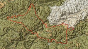
WFIGS perimeter data (updated 2026-09-29) lists the Tartar Fire, Idaho at 158,027 acres with 100% containment. The registry still shows the incident as Active; no public staffing, evacuation, road-closure, or structure-impact details were released. 100% containment indicates active spread was halted but final control and damage status remain unconfirmed.
Current Situation
Per the authoritative WFIGS ArcGIS perimeter feed (last update 2026-09-29T15:18:43Z): incident name Tartar (ID); location ~21 miles NW of Weiser, ID (lat 44.542667, lon -117.121667); reported size 158,027 acres; percent contained 100%; status listed as Active in registry; discovery date 2026-07-24; incident age reported as 1,676 hours in the packet. No additional operational updates (resource assignments, structure counts, evacuations, road closures, or fire behavior narrative) were present in the data provided.
Significant Changes
- Perimeter dataset records containment at 100% as of 2026-09-29 — primary operational change compared with earlier active-spread reporting.
- Final mapped acreage reported at 158,027 acres in the current perimeter feed.
- Registry still lists incident status as Active despite 100% containment notation; the operational implication of that status was not explained in available data.
Operational Concerns
- Confirmed lack of publicly released resource information: Current personnel and equipment assignments have not been publicly released.
- Confirmed information gap on evacuations, road closures, and structure impacts — no authoritative public reporting in packet.
- Assessment: 100% containment reduces active spread risk, but residual hazards (smoldering fuels, interior hotspots, potential for re‑ignition, and suppressed ember sources) typically remain until incident is declared controlled and lines are certified; these remain unverified in the available record.
- Potential administrative/operational lag: registry 'Active' status concurrent with 100% containment may reflect ongoing mop‑up, patrol, rehabilitation, or reporting lag; the reason is not specified in source material.
Operational Outlook
No official operational outlook, demobilization timeline, or transition plan was publicly released in the available ArcGIS perimeter record. Assessment: Given a 100% containment value in the perimeter dataset, command activity commonly shifts toward holding and patrol, mop‑up, structure/property assessments, and repair/rehabilitation of lines and infrastructure; however, these activities are not confirmed by the source and should be treated as analytic inference rather than reported fact.
Public Safety
Evacuations and closures: No evacuation orders, warnings, road closures, or public-safety actions were included in the available authoritative perimeter dataset. Current evacuation status cannot be verified from the provided sources.
Structure exposure: No confirmed information on structures threatened, damaged, or destroyed is present in the available source. Structure impact status is unknown.
Fire Behavior and Weather
The provided ArcGIS perimeter feed reports final acreage and containment but contains no narrative or data describing recent or current fire behavior (rate of spread, flame lengths, spotting, or active fronts). No active fire behavior was documented in the available record.
No weather observations, forecasts, or weather-driven behavior impacts were included in the available perimeter dataset. Weather influence on operations is unreported in the packet.
Resources
Current personnel and equipment assignments have not been publicly released.
Intelligence Gaps
- No official incident command post (ICP) or Incident Management Team status was provided.
- No confirmed personnel or equipment assignment list.
- No public record of evacuations, road closures, or public safety directives.
- No verified structure impact counts (threatened/damaged/destroyed).
- No after-action or mop‑up/rehab status; reason for 'Active' registry status alongside 100% containment is not explained.
- No fire behavior narrative or recent operational reports (patrol, cold-trailing, hotspots) available.
- No weather observations or forecasts tied to final containment assessment.
Sources
- WFIGS Current Perimeters (ArcGIS) — Provided acreage (158,027), percent contained (100%), discovery date, location, and last-update timestamp. No operational staffing, evacuation, structure-impact, or behavior details included.
https://services3.arcgis.com/T4QMspbfLg3qTGWY/ArcGIS/rest/services/WFIGS_Interagency_Perimeters_Current/FeatureServer/0/query?where=attr_ActiveFireCandidate%3D1%20AND%20attr_IncidentSize%20%3E%3D%201000&outFields=attr_IncidentName,attr_IncidentSize,attr_PercentContained,attr_POOState,attr_ModifiedOnDateTime_dt,attr_FireDiscoveryDateTime,attr_IncidentTypeCategory,attr_ActiveFireCandidate,attr_InitialLatitude,attr_InitialLongitude,attr_UniqueFireIdentifier,attr_IrwinID,attr_IncidentShortDescription&returnGeometry=false&resultRecordCount=100&orderByFields=attr_IncidentSize%20DESC&f=json
This page is a continuously updated incident file. Values reflect the most recent verified information available to Fireline Report and may change as agencies publish new data.