0445 CROSSWHITE (OR) — Incident File
0445 CROSSWHITE (OR)
Persistent incident record · Updated 2026-10-02T23:26:37.947Z
Acres
Contained
Assessment confidence
Regional orientation
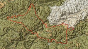
0445 CROSSWHITE (OR) near OR. This map provides regional context; the detailed perimeter map follows when available.
Marker uses the reported incident location. Base map: Esri World Topographic Map.
Bottom Line
The Crosswhite Fire in Oregon burned 342,923 acres and is reported 100% contained (WFIGS ArcGIS, 2026-10-02). Containment indicates established control of the perimeter, but operational details — evacuations, structure impacts, personnel and ongoing mop-up — have not been publicly released.
Current Situation
WFIGS Current Perimeters (ArcGIS) reports: 0445 CROSSWHITE (OR) — 342,923 acres; 100% contained; discovery 2026-07-16; incident status: Active; last registry update 2026-10-02T23:26:37.947Z. Geolocation: 44.803333, -120.199167. No perimeter source update timestamp or geometry was provided in the packet. No official incident action plans, ICS-209, or jurisdictional IMT releases were included in the available record.
Significant Changes
- ArcGIS registry shows containment reported at 100% as of 2026-10-02 (WFIGS Current Perimeters).
- No authoritative public releases available in the packet describing structure impacts, evacuations, or resource demobilization following containment.
Operational Concerns
- Single-source public reporting: only WFIGS ArcGIS perimeter record is available; absence of IMT/ICS-209 or agency press releases creates operational uncertainty for partners.
- Large burned area (342,923 acres) increases the complexity of mop-up, patrol, and rehabilitation even after containment is reported.
- Status discrepancy: incident remains labeled 'Active' while containment is 100%; this can cause confusion for public-safety and logistics planning without clarifying releases.
Operational Outlook
Observed: Public record indicates the incident is mapped at 100% containment and no further mapped growth. Expected/forecast conditions have not been publicly released in available sources. Operational focus where confirmed will likely shift from active suppression to patrol, mop-up, and stabilization, but timing, resource posture, and road/access status are not available in the packet and must be confirmed with the incident management agency.
Public Safety
Evacuations and closures: No evacuation orders, evacuation warnings, road closures, or area closures were included in the available ArcGIS record. Current evacuation status cannot be verified from the provided sources.
Structure exposure: No information on structures threatened, damaged, or destroyed is present in the available record.
Fire Behavior and Weather
No recent fire-behavior reports are available in the provided sources. The reported 100% containment implies no sustained perimeter spread at the time of the ArcGIS update, but specific behavior history and final control actions are not documented in the packet.
No weather observations, forecasts, or weather-driven impacts were provided in the available ArcGIS record.
Resources
Current personnel and equipment assignments have not been publicly released.
Intelligence Gaps
- No IMT or ICS-209 (or equivalent) available to confirm incident objectives, resource assignments, containment timeline, or structure/damage assessments.
- No official public-safety releases (evacuation orders/warnings, road closures) or county/state advisories in the packet.
- No detailed perimeter geometry, ignition point mapping, or timestamps for containment progress beyond the ArcGIS summary.
- No information on rehabilitation, mop-up operations, aviation activity, or utility/infrastructure impacts.
- No after-action, damage, or economic-impact reports available in the provided materials.
Sources
- WFIGS Current Perimeters (ArcGIS) — Provided official recorded acreage (342,923 acres), percent contained (100%), discovery date, incident status and last registry update timestamp; no incident management or public-safety detail included.
Open source ↗
This page is a continuously updated incident file. Values reflect the most recent verified information available to Fireline Report and may change as agencies publish new data.