SINLAHEKIN (WA) — Incident File
SINLAHEKIN (WA)
Persistent incident record · Updated 2026-10-07T01:25:08.243Z
Acres
Contained
Assessment confidence
Regional orientation
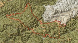
SINLAHEKIN (WA) near WA. This map provides regional context; the detailed perimeter map follows when available.
Marker uses the reported incident location. Base map: Esri World Topographic Map.
Bottom Line
The Sinlahekin wildfire (Okanogan County, WA) is reported at 166,007 acres and 99% containment (last official perimeter update 2026-10-07). The high reported containment indicates the incident is largely controlled, but public-safety orders, resource assignments, and final perimeter securement have not been publicly released.
Current Situation
Incident: SINLAHEKIN (WA). Status: Active. Acres: 166,007. Percent contained: 99. Discovery: 2026-07-26. Location: ~1 mile west of Tonasket, WA (lat 48.6922, lon -119.7137). Last authoritative perimeter update: 2026-10-07T01:25:08Z (WFIGS Current Perimeters via ArcGIS). No official public releases in the provided packet report current staffing, active fire behavior, evacuations, road/area closures, structure damage, or cause.
Significant Changes
- Perimeter registry updated 2026-10-07 reporting containment at 99% — a notable containment milestone from the authoritative perimeter feed.
- No other operational changes (personnel, evacuations, structure impacts) were reported in the available authoritative source.
Operational Concerns
- 99% containment in a single perimeter feed does not confirm final control; unmapped hotspots or weak lines can still pose risk until 100% containment and line hold are confirmed.
- Lack of publicly available information on resource assignments or incident management structure limits situational awareness for partners and infrastructure managers.
- No public reporting of evacuations, road closures, or structure impacts prevents assessment of community exposure and recovery needs.
- Perimeter-only feeds can lag behind on-the-ground status (mop-up, patrol, containment line reinforcement); mapping currency and methods are not specified in the feed.
Operational Outlook
No official operational outlook or forecast was provided in the available record. Based on the reported 99% containment, the likely operational focus (not an instruction) is completion of containment, mop-up, and patrol to secure the remaining perimeter; however, this is an analytical inference not confirmed by published incident orders or briefings. Until official updates are released, the potential for localized smoldering or flare-ups remains an outstanding concern.
Public Safety
Evacuations and closures: No verified information on evacuation orders, warnings, or road/area closures was available in the provided authoritative source. Current public-safety directives could not be confirmed.
Structure exposure: No official reports of threatened, damaged, or destroyed structures were included in the available perimeter data. Proximity to Tonasket (~1 mile) indicates potential community exposure historically, but structure status is unreported and must not be assumed.
Fire Behavior and Weather
The authoritative source provides no contemporaneous description of fire behavior. The 99% containment figure implies limited active spread at the time of the perimeter update, but current on-the-ground activity (smoldering, creeping, isolated torching) was not reported.
No weather or forecast data were provided in the available packet. Potential weather influences on final containment and mop-up operations are therefore undetermined from the supplied sources.
Resources
Current personnel and equipment assignments have not been publicly released.
Intelligence Gaps
- Current incident management team assignment and command structure.
- Confirmed personnel and equipment numbers and staging locations.
- Evacuation orders, warnings, or lift notifications for residents and travelers.
- Road and area closures impacting access to Tonasket and adjacent infrastructure.
- Structure damage assessments and critical infrastructure impacts.
- Detailed perimeter status (locations of outstanding unsecured segments) and recent fire behavior observations.
- Cause and investigation status.
- Recent aerial or ground reconnaissance reports and mapping currency.
Sources
- WFIGS Current Perimeters (ArcGIS) — Provided authoritative acreage (166,007), percent contained (99), incident location, and last registry update timestamp (2026-10-07T01:25:08Z). No operational staffing, evacuation, or damage details included.
Open source ↗
This page is a continuously updated incident file. Values reflect the most recent verified information available to Fireline Report and may change as agencies publish new data.