Active Incidents — Friday, October 9, 2026
Active Incidents
Friday, October 9, 2026 · Updated Oct 9, 2026, 12:32 PM UTC
Selected incidents
Escalating
Operationally significant
National Picture
1 incident show verified escalation signals among 5 nationally selected incidents. The highest-ranked fires are elevated by public-safety exposure, meaningful growth, significant behavior, or low containment rather than acreage alone.
Changes Requiring Attention
- Second Flat (OR): reported growth
Highest-Priority Incidents
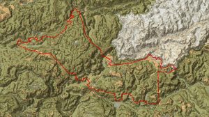
Second Flat fire 99% contained at 105,854 acres in eastern Oregon
Second Flat fire (near Riley, OR) is reported at 105,854 acres and 99% contained in the WFIGS perimeter update (2026-10-09); the incident remains active.Additional operational details are not represented in this report’s source set..
105,854 acres · 99% contained · reported growth · Confidence: Moderate · Source
Little Giant fire 172,906 acres, 93% contained — largely held
The Little Giant fire (near Leavenworth, WA) is reported at 172,906 acres with 93% containment as of 2026-10-09.Additional operational details are not represented in this report’s source set. and remain unresolved.
172,906 acres · 93% contained · source updated 2026-10-09 · Confidence: Moderate · Source
Crosswhite Fire (OR) mapped at 342,923 acres; reported 100% contained
The Crosswhite Fire in central Oregon is recorded at 342,923 acres and listed as 100% contained in the WFIGS perimeter registry (last update 2026-10-02).Additional operational details are not represented in this report’s source set..
342,923 acres · 100% contained · source updated 2026-10-02 · review needed · Confidence: Moderate · Source
Sinlahekin Fire: 166,007 acres, 99% contained (WA)
The Sinlahekin Fire in north-central Washington is reported at 166,007 acres and 99% contained (ArcGIS perimeter update 2026-10-07). This indicates the incident is largely held, but a remaining ~1% (~1,660 acres) of perimeter requires continued monitoring; no public details on resources, evacuations, or structure impacts have been released.
166,007 acres · 99% contained · source updated 2026-10-07 · review needed · Confidence: Moderate · Source
Kaiser Canyon fire (WA) reported 138,293 acres and 100% contained
ArcGIS/WFIGS reports the Kaiser Canyon fire at 138,293 acres and 100% contained as of 2026-09-25. The incident remains listed as Active in the registry; however, no additional official operational updates (personnel, damages, closures) are available in the packet. Key operational status and post-containment actions are unreported publicly.
138,293 acres · 100% contained · source updated 2026-09-25 · review needed · Confidence: Moderate · Source
Regional Incident Environment
Incidents are grouped geographically to show concentrations of activity and shared operational pressure.
Northwest
Second Flat fire 99% contained at 105,854 acres in eastern Oregon
Second Flat fire (near Riley, OR) is reported at 105,854 acres and 99% contained in the WFIGS perimeter update (2026-10-09); the incident remains active.Additional operational details are not represented in this report’s source set..
105,854 acres · 99% contained · reported growth · Confidence: Moderate · Source
Little Giant fire 172,906 acres, 93% contained — largely held
The Little Giant fire (near Leavenworth, WA) is reported at 172,906 acres with 93% containment as of 2026-10-09.Additional operational details are not represented in this report’s source set. and remain unresolved.
172,906 acres · 93% contained · source updated 2026-10-09 · Confidence: Moderate · Source
Crosswhite Fire (OR) mapped at 342,923 acres; reported 100% contained
The Crosswhite Fire in central Oregon is recorded at 342,923 acres and listed as 100% contained in the WFIGS perimeter registry (last update 2026-10-02).Additional operational details are not represented in this report’s source set..
342,923 acres · 100% contained · source updated 2026-10-02 · review needed · Confidence: Moderate · Source
Sinlahekin Fire: 166,007 acres, 99% contained (WA)
The Sinlahekin Fire in north-central Washington is reported at 166,007 acres and 99% contained (ArcGIS perimeter update 2026-10-07). This indicates the incident is largely held, but a remaining ~1% (~1,660 acres) of perimeter requires continued monitoring; no public details on resources, evacuations, or structure impacts have been released.
166,007 acres · 99% contained · source updated 2026-10-07 · review needed · Confidence: Moderate · Source
Kaiser Canyon fire (WA) reported 138,293 acres and 100% contained
ArcGIS/WFIGS reports the Kaiser Canyon fire at 138,293 acres and 100% contained as of 2026-09-25. The incident remains listed as Active in the registry; however, no additional official operational updates (personnel, damages, closures) are available in the packet. Key operational status and post-containment actions are unreported publicly.
138,293 acres · 100% contained · source updated 2026-09-25 · review needed · Confidence: Moderate · Source
Data note: WFIGS provides mapped perimeter status, not a complete operational briefing. Source-update times are shown for each item; reports older than 48 hours require editorial review. Containment describes perimeter, not uncontained acreage. Acreage and containment may change after publication.