Southern California heat peaks today; Riverside gusts add the clearest fire-weather concern
TODAY'S FIRE WEATHER BRIEF
Southern California heat peaks today; Riverside gusts add the clearest fire-weather concern
Hot inland temperatures near 100 to 106 degrees are the main operational signal today from Bakersfield and the Los Angeles metro edge to Riverside and Palm Springs. The Inland Empire stands out because the Riverside forecast adds west winds
Hot inland temperatures near 100 to 106 degrees are the main operational signal today from Bakersfield and the Los Angeles metro edge to Riverside and Palm Springs. The Inland Empire stands out because the Riverside forecast adds west winds up to 15 mph with gusts to 25 mph, while Duluth, Minnesota, and Albany, New York, show notable wind gusts but no SPC Day 1 fire-weather risk area.
Morning assessment
The national pattern is localized rather than widespread: the Storm Prediction Center lists no Day 1 fire-weather risk areas, and the provided local NWS samples show no Red Flag Warnings or fire-weather watches. Even so, several forecast points carry enough heat or wind to matter for initial attack and short-duration fire behavior.
The most important change today is the combination of peak afternoon heat and localized west gusts around Riverside. Other Southern California forecast points are hot but show lighter winds in the samples, making terrain-channeling and ignition location the main uncertainties.
Areas of greatest concern
Riverside and the Inland Empire valley margins
Riverside is the highest-priority point in today’s sample: high near 102 degrees, west wind 0 to 15 mph, and gusts as high as 25 mph. The main window is this afternoon during peak heating, when chaparral, brush and grass on wind-exposed slopes, ridgelines and valley-adjacent terrain can show faster surface spread if an ignition occurs.
Reason-and-timing line: Heat plus localized west gusts are the driver near Riverside and Inland Empire margins this afternoon; the key uncertainty is how consistently those gusts develop across terrain rather than at the forecast point alone.
Palm Springs, Bakersfield and the Los Angeles metro edge
Palm Springs is forecast near 106 degrees, Bakersfield near 100, and the Los Angeles sample near 98 with light south to southeast wind. These locations are heat-dominated in the provided forecasts, with no active fire-weather alerts in the sample set.
Reason-and-timing line: The driver is very hot daytime weather across desert, valley and metro-edge fuels today; the uncertainty is whether local canyon, pass or valley winds exceed the lighter winds shown in the point forecasts.
Duluth and Albany wind points
Duluth is forecast near 65 degrees with west winds 10 to 15 mph and gusts up to 35 mph. Albany is forecast near 64 degrees with south winds 5 to 13 mph and gusts up to 25 mph.
Reason-and-timing line: The driver is daytime wind, not heat, in the Minnesota and New York forecast samples; the key uncertainty is fuel receptiveness because SPC did not identify a broader critical fire-weather setup.
What to watch through tonight
– Riverside and nearby Inland Empire slopes: whether afternoon west gusts reach the forecast 25 mph and align with grass, brush or chaparral runs near valley margins.
– Bakersfield and Southern Sierra pass areas: whether local pressure gradients or canyon winds become stronger than the light northwest winds in the point forecast.
– Los Angeles metro edge and Transverse Range exposures: whether light forecast winds stay weak or become locally channeled along terrain during the warmest part of the day.
– Palm Springs and Phoenix: heat is the main signal, with highs near 106 and 101 respectively; ignition occurrence is the decision point because winds are light in the samples.
– Duluth and Albany: watch for short periods when forecast gusts — up to 35 mph near Duluth and 25 mph near Albany — coincide with dry fine fuels, even though no SPC fire-weather risk area is in effect.
Fuel and drought context
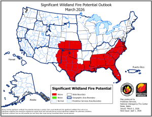
Drought and fuel dryness are background factors, not proof of critical fire weather today. The U.S. Drought Monitor shows moderate drought in parts of California, with 23.3% of the state in D1 or worse, while broader western and Southern Plains dryness remains part of the national fuel picture; the eastern wind points require local fuel-moisture judgment because the national outlook does not support a widespread fire-weather escalation there.
Bottom line
Today’s operational focus is Southern California heat, especially the Riverside area where afternoon west gusts add a wind component; elsewhere, Duluth and Albany may see locally meaningful gusts, but the national fire-weather outlook remains below SPC risk thresholds.
Information is for situational awareness and should not replace official forecasts, warnings, or operational decision-making.